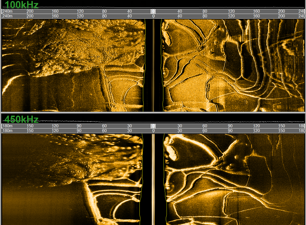
The Leader of Underwater Technology in China

   中文 | English  

Side Scan Sonar

Shark-S100DP Deep-Water Dual-Frequency Side Scan Sonar

  • Description
  • Features
  • Specifications
  • Application
  • Download

    Shark-S100DP Deep-Water Dual-Frequency Side Scan Sonar is a versatile sonar system designed for surveys in deeper waters. It features dual-frequency (100 kHz and 400 kHz) simultaneous transmission and reception, along with Chirp modulation processing technology, enabling wide swath coverage while ensuring high-resolution imaging.

    The sonar system features a rugged stainless-steel towfish, armored Kevlar cable, splash-proof deck unit, and intuitive OTech software. Engineered for durability and reliability, the towfish supports multiple mounting options, including towing, bottom deployment, and side-hull installation. The Shark-S100DP can be optionally equipped with a USBL positioning system, and a magnetometer interface is available for seamless integration with external magnetometers. A towing overload protection structure is incorporated to effectively safeguard against impacts. The towfish is hydro-dynamically designed to ensure stable towing performance. The system can be powered by either AC mains or a battery-powered inverter, while maintaining exceptionally low power consumption.

    The proprietary OTech software combines ease of use with powerful functionality, offering features such as real-time image mosaicking, sonar image waterfall display, survey line planning and navigation, track tracking and coverage display, data recording and playback, target management and export, and multi-window sensor information display. The software utilizes adaptive equalization processing technology to ensure consistent image quality across both near and far ranges. With minimal parameter settings and a user-friendly UI design, it is straightforward to operate. It supports output in the standard XTF format, compatible with third-party post-processing software. The enhanced version of the software can output multiple raw data formats in real time for the development of AI-based automatic target recognition

    Key Features
    • Dual-frequency simultaneous operation, enabling both wide-swath coverage and high-resolution seabed imaging
    • Seamlessly integrates with magnetometer and USBL positioning systems
    • Integrated single-beam echosounder for accurate bottom-tracking
    • 316L Stainless Steel Towfish – Rated for 2,000-meter operations, with customization available for 6,000-meter depths.
    • Supports real-time mosaicking, raw data output, and SDK development

    Sonar Specifications

    Shark-S100DP

    Operating Frequency

    100kHz & 400kHz dual-frequency simultaneous operation

    Pulse Type

    LFM (Chirp) / CW

    Maximum Range

    600m @100kHz,200m @400kHz

    Beamwidth

    Horizontal: 0.6° @100kHz, 0.2° @400kHz

    Vertical: 50°

    Resolution

    Along-track resolution: 0.01h (range) @100kHz, 0.003h @400kHz;

    Across-track resolution: 2.5cm @100kHz; 1.25cm @400kHz

    Transducer Mounting Angle

    Adjustable downward angles of 10°, 15°, or 20° (factory set to 20°)

    Maximum Operating Depth

    2000m (Customizable up to 6000 meters)

    Standard Built-in Sensors

    Single-beam echosounder, attitude sensor (pitch, roll, heading), pressure sensor
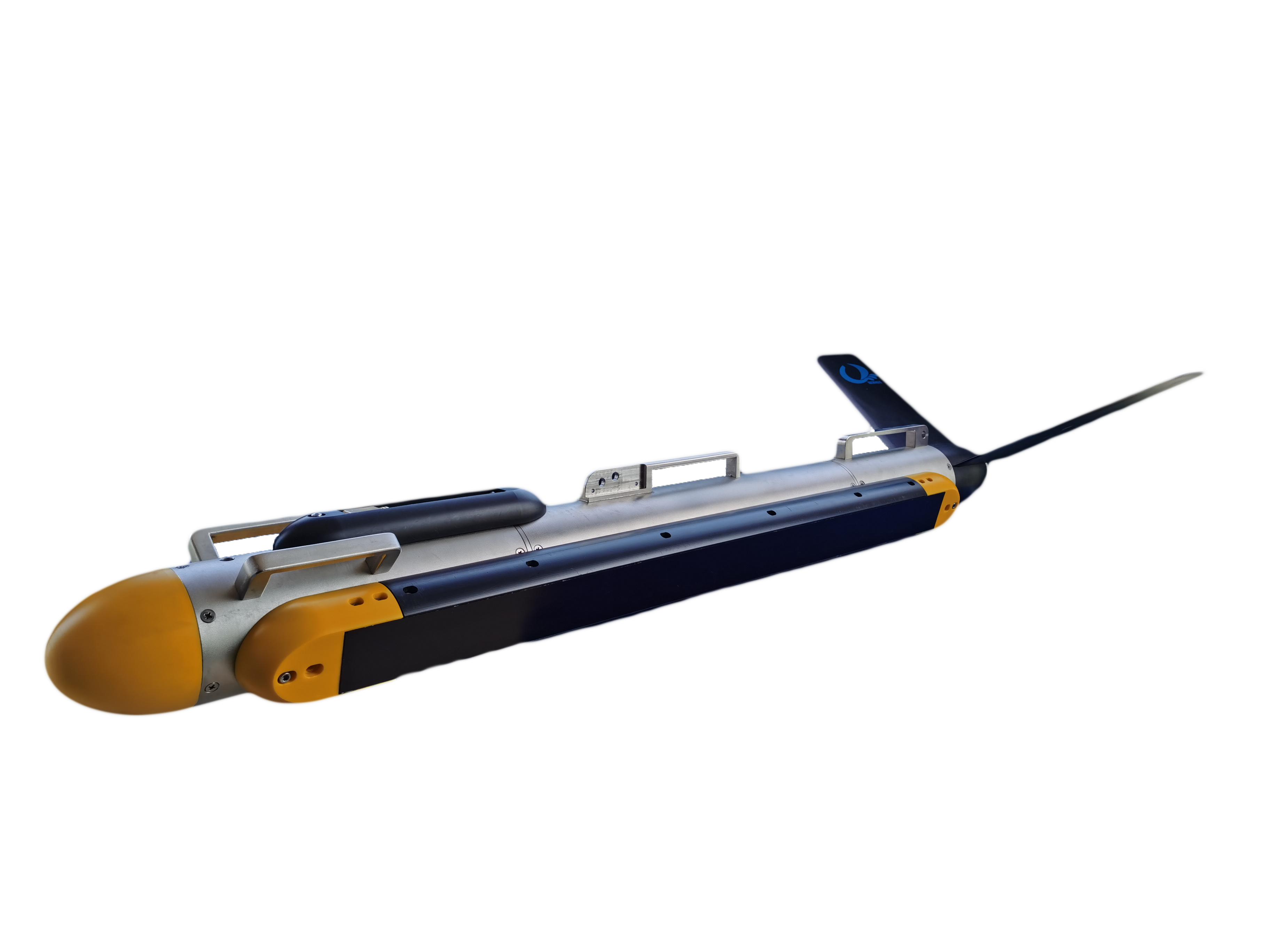
    Towfish Dimensions / Weight

    1283mm(L)×120mm(Dia.) / 50kg (316L stainless steel)

    Deck Unit Dimensions / Weight

    248mm(L)×192mm(W)×70mm(H) / 1.9kg

    Power Supply / Consumption

    220/110VAC, 60W

    OTech Software

    Real-time mosaicking; live online mapping; OTSS and XTF formats recording; SDK development support; continuous raw data output.

    Interface

    Ethernet Interface; optional magnetometer interface

    Tow Cable

    Armored Kevlar cable, 100 meters (customizable); optional winch available

    Applications
    • Military applications, mine countermeasure detection, and target scanning
    • Maritime channel management, scanning of wrecks and sunken containers
    • Marine geological and geophysical surveys
    • Archaeological investigations, such as underwater ancient city and shipwreck searches
    • Route surveys for cable and pipeline installation and maintenance
    • Seabed topographic surveys for offshore wind farms and other renewable energy sites
    • Structural inspection of underwater facilities including dams and power plants